News
https://www.bbc.co.uk/news/articles/cy5kw46qxppo
BBC: What does it take to fix a city's ancient walls ?
Chester's Roman wall collapses after digging work
On Thursday 16th January 2020 a small section of the East City Walls to the rear of the Grosvenor Shopping Centre collapsed. The section has been cordoned off.
https://www.bbc.co.uk/news/uk-england-merseyside-51152431?intlink_from_url=&link_location=live-reporting-story

Map of Chester
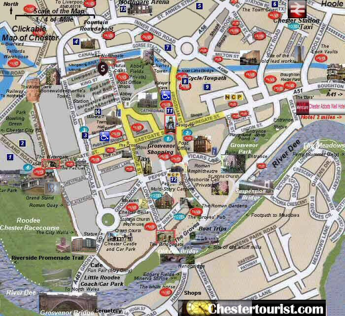
Key  City Walls City Walls  Shops Shops  Parkland and open spaces Parkland and open spaces  Google Map of Chester Google Map of Chester
Hotels in the City Centre
 The Chester Grosvenor Eastgate Chester CH1 1LT

 Blossoms Hotel St John Street Chester CH1 1HL
 Crowne Plaza Trinity Street Chester CH1 2BD
 Express By Holiday Inn, Chester Race Course, Chester, CH1 2LY
Parking in the City Centre
The 351 space Delamere Street Car Park in Chester is now open.
New Hoole Bridge Public Car Park 24 hour parking for Chester Railway Staton.
Crewe Street Car Park has closed
Gorse Stacks Car Park is now closed
 Racecourse 500 Spaces Pay on Entry Racecourse 500 Spaces Pay on Entry
 Watergate (Crane Street) 128 Spaces Pay & Display (restricted height) Watergate (Crane Street) 128 Spaces Pay & Display (restricted height)
 Trinity Street 148 Spaces Pay & Display Trinity Street 148 Spaces Pay & Display
 Garden Lane 126 Spaces Pay & Display Garden Lane 126 Spaces Pay & Display
  St Anne Street (Brook Street) Street 137 Spaces Pay & Display St Anne Street (Brook Street) Street 137 Spaces Pay & Display
 Chester Station Chester Station
 Tesco Supermarket 550 Pay on Exit Tesco Supermarket 550 Pay on Exit
  Browns Yard NCP 60 Spaces Pay on Exit (24 Hours Unrestricted Height) Browns Yard NCP 60 Spaces Pay on Exit (24 Hours Unrestricted Height)
  Frodsham Street Spaces 82 Pay & Display Frodsham Street Spaces 82 Pay & Display
 Pepper Street NCP Spaces 288 Pay on Exit Pepper Street NCP Spaces 288 Pay on Exit
 Northgate Arena Spaces 210 Pay on Exit Northgate Arena Spaces 210 Pay on Exit
 Market (Princess Street) Car Park Pay and Display (Restricted to car height, Pay on Foot, 1.9m Locked 11:30pm to 6:30am) Market (Princess Street) Car Park Pay and Display (Restricted to car height, Pay on Foot, 1.9m Locked 11:30pm to 6:30am)
 Cuppin Street Short Stay Pay and Display Car Park Cuppin Street Short Stay Pay and Display Car Park
 Newgate Street Car Park Newgate Street Car Park
 Little Roodee Car and Coach Park (Unrestricted Height, Locked at Night) Little Roodee Car and Coach Park (Unrestricted Height, Locked at Night)
Coach Drop Off Points
There are three coach drop off points in the City Centre.
1 - Junction of Northgate Street and Princess Street outside the old Odean Cinema
2 - Grosvenor Street
3 - Foregate Street outside of Argos
Blue Badge Parking
Hamilton Place CH1 2BG 9 Spaces Free 4 hour parking for Blue Badge holders
Frodsham Street 82 Spaces
Private Car Parks
 Linnenhall Car Park 250+ Spaces New Crane Street CH1 2LP Linnenhall Car Park 250+ Spaces New Crane Street CH1 2LP
Pay and Display 50 Spaces Canal Street Chester CH1 4EJ
NCP Car Park Information

Lost Property
0300 123 7024
Car / Coach Parking
The Little Roodee Coach / Car Park
Click here for more information
Motorhome Parking
Please click for more information
www.motorhomeparking.co.uk
Park and Ride Locations
English over 60's bus passes may be used with restrictions
Please click on a location for more information

Parking More Information
More information on the Park and Ride
More Information
http://www.cheshirewestandchester.gov.uk/residents/transport_and_roads.aspx
A map of the City of Chester (Roman name Deva), which is located in the northwest of England on the border of England and Wales. The Romans founded the city in 43AD by the second legion, at the lowest bridgeable point in a defensive bend in the River Dee.
The Romans first constructed a wooden and earth fortress to house the invading legion. The fortress was then replaced by a fortress built out of the local sandstone. Parts of the original fortress wall and ditch can still be seen in places. The Romans occupied the fortress to subdue Wales, Northern England and possibly Ireland until the fifth century. After the Romans left the fortress went into decline and much of the stone was robbed for Saxon buildings. The walls were extended in Saxon times, to increase the area of protection and also because the River Dee was retreating.
In 875 the remains of St Werburgh were transferred to the City from Hanbury for safe keeping when the Danish invasions started. A shrine was built to house the remains and the City became a place of pilgrimage.
In Norman times a castle was added on a sand stone hill in the south west of area inside the walls. A Norman Abbey was founded in the northwest of the City.
Chester because a busy port again in medieval times. The Water Tower and Spur Wall were added to keep watch over the port of Chester. The City retained some of the Roman street plan e.g. Northgate Street, Eastgate Street, Watergate Street, Bridge Street. The Old Dee Bridge was constructed of local sandstone to the south of the city.
The Kateyard Gate was added to allow the monks access to the kale plants growing outside the walls.
In the 16th Century the River Dee began to silt up and ships could no longer reach the port. The development of the City was frozen as trade switched to other ports like Liverpool. The area recovered from the River was used for horse racing. Today it is the oldest racecourse in the country. The Abbey was closed and became a Cathedral. It retained is cloisters, but the Werburgh shrine was smashed up. The Abbey Gateway was retained and is visible today.
During the English Civil war the City was on the side of the king. After the Battle of Rowton Moor in 1645 the city was under siege. The walls and city were pounded by cannon and grenades. When it surrendered the High Cross was taken down and hidden, churches were damaged.
In the eighteenth Century the four medieval gateways Northgate, Watergate. Bridgegate, Eastgate were pulled down and replaced by arches to allow more traffic into the city. The Shropshire Union canal was added, which used in places the Roman defensive fortress ditch.
The Grosvenor Bridge was added, and it the time was the longest single span bridge in the world. Industrial areas and domestic housing sprang up outside the city walls. All of Chester Castle was demolished apart from the keep and rebuilt. The Castle gateway was rebuilt in the Greek style.
In the 1960's the Victorian Market Hall was demolished and replaced.
The High Cross was restored to its original position only in the 1970's.
In the 1980's and 1990's parts of the city centre were pedestrianised.
After the millennium the Roman Gardens were re-modelled. And the Roman Amphitheatre was re-excavated.
Mail Order Maps from Chester City Council Chester Tourism
Chester City Council stock a wide range of saleable maps and guides to help you enjoy your visit to the historic city and get the most out of your stay. Chester is also the ideal touring base, perfect for exploring North Wales and Wirral and the County towns of Cheshire and we stock several titles on these areas.
All maps and guides are despatched by 1st class return post to ensure a fast, efficient service.
Other Chester Guides
Chester Day and Night Guide
 Rough Guide LTD Chester Destination Guide Rough Guide LTD Chester Destination Guide
Related Pages
A Clickable Map of the Walls
A map of Olde Tyme Chester
A Clickable Map of the Walls
An Old Map of Chester's City Walls
Walk the Walls


|